Driving along Oregon 18 in the fall, near mile-marker 25, travelers might catch an unexpected sight: a smiley face in the trees. Nestled between the towns of Grand Ronde and Willamina, this cheerful emblem isn’t a natural phenomenon but a cleverly designed masterpiece of forestry. Stretching 300 feet in diameter, the face grins brightly from the hillside every autumn, its eyes and mouth a deep green surrounded by golden yellow. The secret? A combination of Douglas fir and larch trees planted precisely to create the illusion. The face was the brainchild of David Hampton, co-owner of Hampton Lumber, and Dennis Creel, the company’s then-timberland manager. In 2011, the pair collaborated to bring this whimsical idea to life. …“Passersby will be able to see the smiling face every fall for the next 30-50 years,” Hampton Lumber’s Kristin Rasmussen said. After that, the trees will be harvested and processed into lumber at Hampton’s nearby sawmills.

 Firefighters in southern California are battling the Palisades and Eaton Fires. …Residents of many fire-prone areas have grown familiar with the orange, apocalyptic haze of wildfire smoke as these blazes have become more common because of climate change. Such smoke can contain an unpredictable cocktail of chemicals associated with heart and lung diseases and even cancer, which is the leading cause of death among firefighters. Here’s what makes wildfire smoke so dangerous. When trees, shrubbery and other organic matter burn, they release carbon dioxide, water, heat—and, depending on the available fuel, various volatile compounds, gaseous pollutants and particulate matter. Those tiny particles, which become suspended in the air, can include soot (black carbon), metals, dust, and more. If they’re smaller than 2.5 microns in diameter, they can evade our body’s natural defenses when inhaled, penetrating deep into the lungs and triggering a wide variety of health problems.
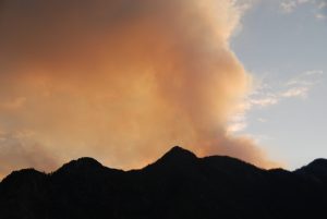 PACIFIC PALISADES, California − Firefighters were progressing in their battle against two massive wildfires as winds eased early Thursday, bringing a respite to frustrated and beleaguered residents across Los Angeles County who have been on edge for over a week. All “particularly dangerous situation” red flag warnings largely expired by Wednesday night without causing any significant fire growth, according to the National Weather Service. But dry conditions and locally gusty winds were forecast to linger into Thursday − particularly in the mountains, the weather service warned. According to the weather services, temperatures were also expected to drop five to 10 degrees below normal for the remainder of the week, and Friday is predicted to be the coldest. “Good news,” the weather service’s Los Angeles office said. “Bad News: Next week is a concern. While confident that we will NOT see a repeat of last week, dangerous fire weather conditions are expected.”
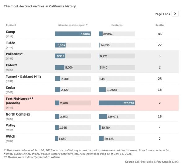 Foreboding weather forecasts keep tensions high in Los Angeles as one of North America’s largest cities battles wildfires that have already claimed at least two dozen lives and thousands of homes. Here are some data points that put into context the peril the city is in. The most destructive fires in California history — and how they compare to Canada’s largest wildfire: Palisades and Eaton fires are already among the most destructive in California’s history, scorching more than 10,000 structures in just a matter of days. With persistent winds in the forecast, those numbers could climb even higher. For context, Canada’s most devastating wildfire — in Fort McMurray, Alta., in 2016—destroyed an estimated 2,400 structures.
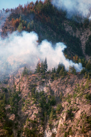 Fires burning homes and businesses in Los Angeles for a week have killed at least 24 people, displaced thousands of others and destroyed more than 12,000 buildings in what might be the most expensive conflagrations in the nation’s history. The blazes started Jan. 7, fueled by fierce Santa Ana winds that have posed problems for the large forces of firefighters deployed across several areas of the sprawling city. Cal Fire reported that the Palisades, Eaton, Kenneth and Hurst fires have consumed about 63 square miles (163 square kilometers). Investigators are still trying to determine what sparked the fires. They could be the nation’s costliest ever.