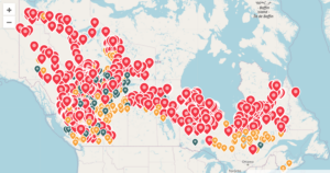
 A map updated daily by the Canadian Interagency Forest Fire Centre shows how widespread the wildfires have become. Eastern provinces like Quebec, Ontario and Nova Scotia have been hit particularly hard this year by large and at times uncontrollable blazes. Officials on Monday reported 372 active fires in British Columbia, along Canada’s west coast. To the east, Alberta had the second-highest number of active blazes with 121 while Quebec, which borders New England, had 108. …As of its most recent update, the interagency fire center has recorded 4,148 wildfires since the beginning of 2023. The fires have scorched at least 10 million hectares — or over 24.7 million acres — of land across Canada this year. In June, the acreage burned this year surpassed the amount of land burned in 1989, which previously held Canada’s annual record, the country’s National Forestry Database reported.