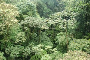
 Recently, Meta has developed an AI-powered canopy height map that offers unprecedented detail in tracking forest health and carbon storage. This open-source tool helps project developers monitor changes, verify carbon credits, and boost climate action… Meta’s model has been validated with mean absolute errors of 2.8 meters in U.S. forests and 5.1 meters in Brazil. This reflects a promising improvement in estimating canopy height at fine scales… Experts want clearer standards for how datasets can be used. They also seek better reporting on uncertainty and clearer rules for issuing carbon credits. A global benchmarking database with verified data and a central portal for quality datasets could help boost adoption. Moreover, easier AI tools would make this process smoother. Integrating advanced models like Meta’s into accessible platforms, alongside collaborative standard-setting, will be crucial to scaling reliable forest carbon monitoring and verification.