Category Archives: Forest Fires

Forest Fires

Expert warns of ‘extreme fire danger’ as heat wave pushes B.C. wildfire risk to dangerous levels

Global News
June 30, 2021
Category: Forest Fires
Region: Canada, Canada West

The unprecedented heat wave in B.C. has pushed the risk of wildfire to dangerous levels, according to a University of British Columbia professor. Lori Daniels, a professor with UBC’s department of forest and conservation sciences, said the fire danger rating for nearly the entire province is classified as either high or extreme and that British Columbians need to do everything they can to avoid any activity that could spark a fire. “Now is the time to be very, very careful about fire,” she said. According to Daniels, B.C.’s current fire danger map looks similar to maps from August 2017 and August 2018, two of the worst wildfire seasons on record. Daniels said the province had a drier than normal spring with parts of B.C.’s Interior receiving one-fifth of their normal rainfall during May and June. “We put this heat on top of it and we’re in an extreme fire danger and we’re seeing that now with fires starting in different parts of the province,” she said.

Read More

New evacuation orders issued in western Canada as fire guts town after record heat

Reuters
July 2, 2021
Category: Forest Fires
Region: Canada, Canada West

A forest fire that began after three days of record-breaking temperatures has destroyed most of the small western Canadian town of Lytton, as government officials issued fresh evacuation orders on Thursday as more wildfires tore through the province. More than 1,000 people in and around Lytton, in central British Columbia, were evacuated late on Wednesday after the fast-moving fire engulfed the community, catching residents by surprise. The cause of the fire was being investigated, B.C Premier John Horgan told reporters. …”The town has sustained structural damage and 90% of the village is burned, including the centre of the town,” Brad Vis, a member of Parliament for Mission-Matsqui-Fraser Canyon, said in a Facebook post. …Horgan said 62 new fires were reported in B.C. in the past 24 hours, forcing authorities to issue new evacuation orders affecting some 700 people in B.C.’s Cariboo region. …Amateur video footage showed residents of Lytton scrambling to leave town in cars as fires burned down trees and some structures.

Additional coverage in the Victoria Times Colonist by the Canadian Press: Fire destroys most of Lytton; anguished son recalls seeing parents trapped

Read More

Wildfires burning in Graystokes Provincial Park east of Kelowna now listed at 1,400 hectares

By Doyle Potenteau
Global News
July 1, 2021
Category: Forest Fires
Region: Canada, Canada West

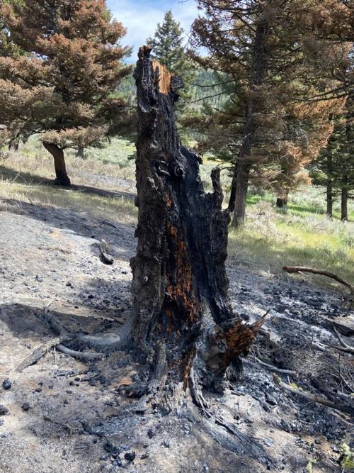
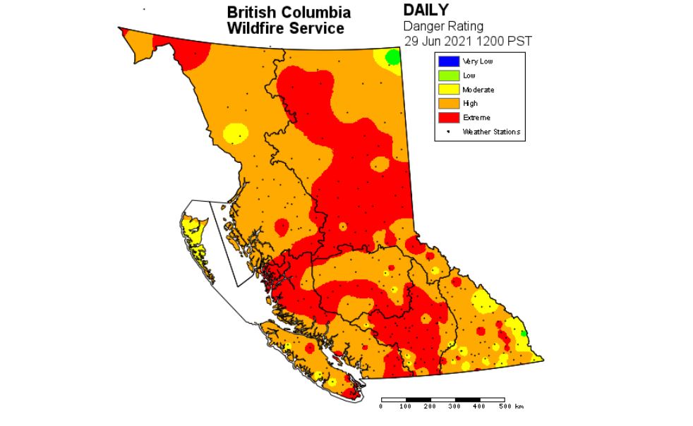
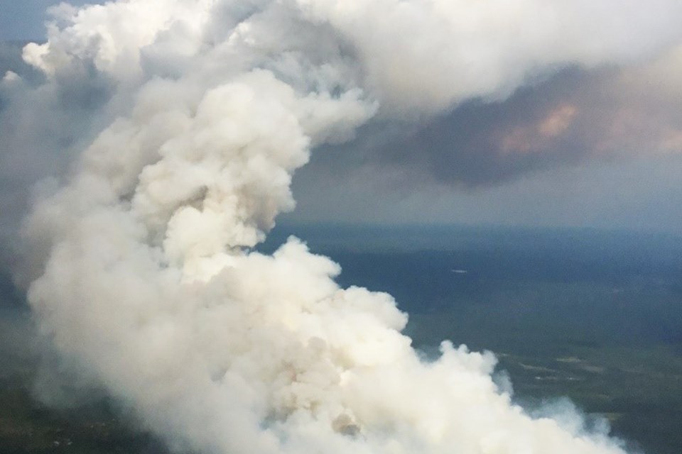
Three hours after estimating the size of three wildfires burning east of Kelowna, BC Wildfire updated its measurements Thursday afternoon. In an interview with Global News, BC Wildfire said the combined size of the three separate fires is 1,400 hectares — up from 150 hectares in the morning. All three — Hilda Creek, Long Loch (300) and Derickson Lake (100) — were discovered Tuesday and were initially small before exploding in size on Wednesday. At one point, BC Wildfire pegged the Long Loch and Derickson Lake wildfires at a combined 400 hectares, but then told media Thursday morning that the fires were around 150 hectares in size. Then in the afternoon, that was upgraded to a combined 1,400 hectares. …Seven kilometres southeast of that fire is the Derickson Lake wildfire, which is now listed at 1,300 hectares, up from the morning’s updated estimate of 50 hectares. It’s located around 18 km north of Big White, and is also deemed out of control.

Read More

Sparks Lake fire grows to 2,300 hectares; evacuation orders, new alerts in place

By Coulton Davies
RadioNL
June 29, 2021
Category: Forest Fires
Region: Canada, Canada West

In an update late Tuesday night, the BC Wildfire Service says the Sparks Lake wildfire has grown again, to 2,300 hectares in size.  That is triple the previous size estimate of 750 hectares this afternoon, and much higher than the estimated size of 350 hectares just 12 hours ago.  There were nine properties put on evacuation order at about 4 p.m., and 150 other properties have now been placed on evacuation alert.  Homes on an evacuation order include 7501, 7560, 7645, 7750, 8088, and 8092 Tranquille Criss Creek Road, 7900 and 8185 Seven Lakes Road and 4000 Leblond Road. Residents at those properties have been asked to check in at the McArthur Island Events Centre in Kamloops.  The properties on evacuation alert are in the Deadman, Red Lake, Vidette Lake and Tranquille Valley areas. Details from the Thompson-Nicola Regional District can be found here.  

Read More

Fire north of Lillooet explodes to 5,000 hectares on first day, evacuations ordered

By Kristen Holliday
Castanet Kamloops
June 29, 2021
Category: Forest Fires
Region: Canada, Canada West

The Mckay Creek Fire north of Lillooet has exploded to 5,000 hectares in size. The growth of the fire, fuelled by record hot temperatures, has been remarkably fast since it was discovered Tuesday. The Squamish Lillooet Regional District has issued evacuation orders for a large area spanning from the 14 km mark on West Pavilion Road to the SLRD border with Thompson-Nicola Regional District. Residents are being told to evacuate along West Pavilion Road towards Lillooet. RCMP from Pemberton are helping with the evacuations.

Read More

Wildfire near Kamloops grows to 180 hectares, evacuation alert issued

Kamloops This Week
June 28, 2021
Category: Forest Fires
Region: Canada, Canada West

BC Wildfire Service crews are battling an out of control fire near Red Lake, about 15 kilometres north of Kamloops Lake. The Sparks Lake fire was estimated at 40 hectares as of 7:45 p.m. on Monday. There are 27 BC Wildfire personnel fighting the fire, which is centred in a thick stand of trees. In addition, there are a number of aircraft and heavy equipment on the ground aiding in the effort. The BC Wildfire Service said there are no structures threatened as of 7:45 p.m. Thick, white smoke from the blaze can be seen from Kamloops.

Read More

Wildfire not moving and evacuated residents between Evansburg and Wildwood allowed to return home

By Glenn Werkman
Edmonton Journal
June 23, 2021
Category: Forest Fires
Region: Canada, Canada West

Residents of an area between Evansberg and Wildwood evacuated because of a wildfire were told by Yellowhead County they could return home at 7 p.m. Wednesday. The 181-hectare wildfire continued to burn out of control but was not moving Wednesday in the Edson forest area nine kilometres west of Evansburg, about 100 kilometres west of Edmonton. “The wildfire is not moving at this time,” said Alberta Wildfire information officer Colby Lachance in a Wednesday afternoon update. Thirty-two firefighters were engaged in suppression and containment efforts Wednesday afternoon, aided by six air tankers and four helicopters. The blaze crossed the Lobstick River Tuesday evening and is currently burning north of Highway 16 and west of Highway 22. There is some fire activity in the interior of the area but the majority of the fire is smouldering on the outskirts, she said.

Read More

Crews battling new BC wildfires near Kamloops, Hope

By Simon Little
Globalnews.ca
June 23, 2021
Category: Forest Fires
Region: Canada, Canada West

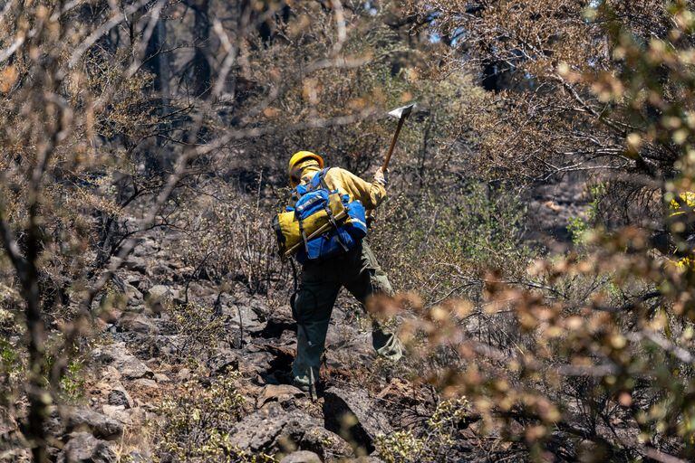
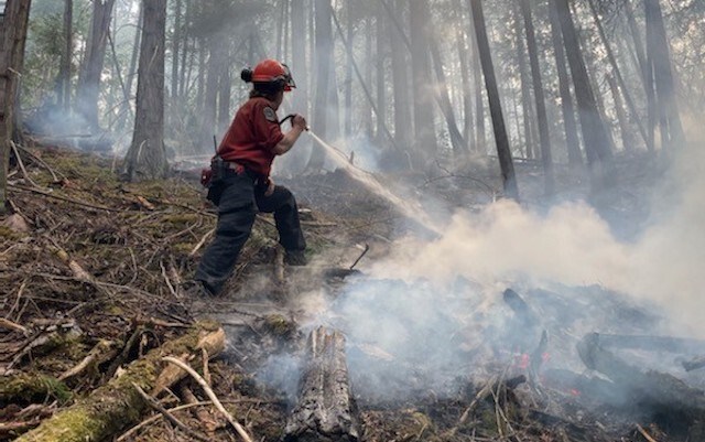
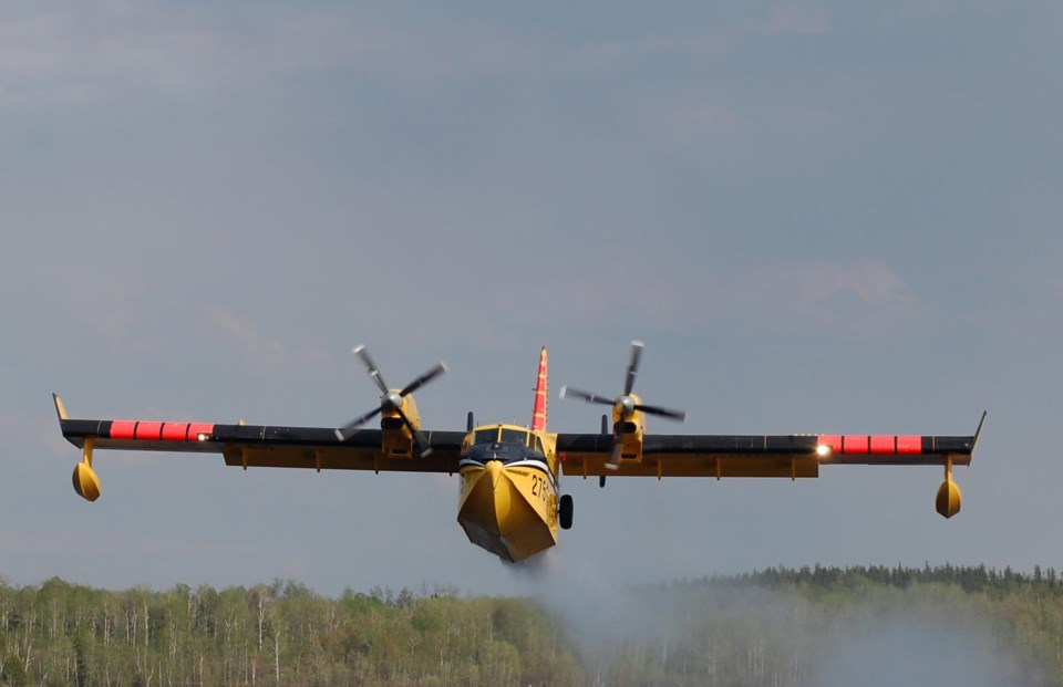
BC Wildfire Service crews were on scene battling several new out-of-control wildfires on Wednesday. Crews were called to an area 11 kilometres southwest of Kamloops, where an 0.5 hectare fire was burning next to the Coquihalla Highway. Near Nelson in the West Kootenay, crews were battling the 0.5 hectare Balfour Knob fire, located four kilometres north of Balfour. Smoke from the fire was visible from Nelson, but no structures were threatened… The fire is believed to have been caused by lightning. Crews were also about 13 kilometres southeast of Hope Wednesday, fighting the Eleven Mile Creek fire. That fire … had grown to 50 hectares in size, and burning away from Highway 3 in steep, rugged terrain. The BC Wildfire Service said smoke from the fire was highly visible from the highway. Sixty-one firefighters were on scene, with the support of four helicopters. No structures were threatened.

Further coverage:

Read More

‘Out of control’ fire at Eleven Mile Creek near Hope up to 35 hectares

By Eric Welsh & Paul Henderson
The Chilliwack Progress
June 22, 2021
Category: Forest Fires
Region: Canada, Canada West

A wildfire that was discovered Sunday (June 20) near Hope is now burning out of control and as of Tuesday was 35 hectares in size. The blaze is located around Eleven Mile Creek, which is halfway between Hope and Sunshine Valley. Going east on Highway 3, the area is accessed by a forest service road and is a hiking and all-terrain vehicle destination. On Monday on the provincial government’s B.C. Wildfire Dashboard web page, it was listed at 20 hectares and is one of two fires currently classified as out of control. A Tweet from the BC Wildfire Services Tuesday just before noon said it had nearly doubled in size.

Read More

Wildfire near Lytton grows to 110 hectares; evacuation alerts in place

By Tim Petruk and Kirsten Holliday
Castanet
June 21, 2021
Category: Forest Fires
Region: Canada, Canada West

All evacuation alerts issued for properties around the George Road wildfire near Lytton have now been lifted. Earlier this evening, the Lytton First Nation rescinded evacuation alerts it had issued for IR 20, Kitzowit. That followed a decision by the Thompson-Nicola Regional District early this morning to rescind an evacuation alert for 10 homes in Electoral District I. In an update Monday evening, the BC Wildfire Service indicated crews had made good progress on workable areas of the fire while helicopters continued to bucket the “inoperable, steep parts of the fire.” “As the hot weather persists, increased fire behaviour may be visible in the inoperable areas of the east flank. “This is behaviour that is expected and accounted for in the long-term monitor and modified response strategy.”

Read More

Eighty-hectare ‘out-of-control’ wildfire near Lytton, B.C. prompts evacuation alert

By Simon Little
Global News
June 17, 2021
Category: Forest Fires
Region: Canada, Canada West

An evacuation alert has been issued for 10 properties near Lytton, B.C., as crews work to tackle an out-of-control wildfire. The Thompson-Nicola Regional District said Thursday the fire threatened structures and residents in Electoral Area “I” (Blue Sky Country). Residents were warned to prepare essential items and to be ready to leave with a moment’s notice. The BC Wildfire Service said the fire — the first “wildfire of note” of the season — was burning about seven kilometres south of Lytton, and adjacent to Highway 1. As of Thursday evening, it was 80 hectares in size, and burning in steep terrain that was challenging for crews to access.

Read More

Alberta deploys 81 firefighters to help battle wildfires in Ontario Social Sharing

CBC News
June 13, 2021
Category: Forest Fires
Region: Canada, Canada West

Alberta has deployed 81 firefighters to help battle wildfires in northern Ontario. On Thursday, 41 wildland firefighters were deployed to the province and on Sunday another 38 firefighters and two support staff joined them. Ontario had submitted a request for assistance to the Canadian Interagency Forest Fire Centre (CIFFC) after a number of lightning strikes caused several new fires, according to the province. …There have been 330 wildfires in Ontario so far this year, well above the 10-year average of 207 fires in a season, which runs April through October. There are 31 active fires in the province’s northwest region, which is where the Alberta firefighters have been deployed, seven of which are not under control. One fire, which has grown to 2,410 hectares, is located just 45 kilometres from the town of Nipigon. 

Read More

B.C. deploys more than 200 wildfire fighters to Quebec and Ontario

CBC News
June 12, 2021
Category: Forest Fires
Region: Canada, Canada West

British Columbia is deploying more than 200 personnel to help fight wildfires in Ontario and Quebec.   In a written statement, the Ministry of Forests, Lands, Natural Resource Operations and Rural Development said it was sending 184 firefighters on Friday and Saturday, and another 20 on Sunday.   “COVID-19 precautions will be taken to protect the health of everyone participating, both during their time in Central Canada and on their return to this province,” the ministry said.  “Firefighters will remain within their own ‘bubbles’ and conduct operations separately from Quebec and Ontario firefighters.”  The ministry says the province recognizes the importance of sharing firefighting resources across jurisdictions. Last month, it sent crews to Manitoba. The personnel can be recalled at any time if they’re needed back in B.C., the ministry says. 

Read More

Wildfire service outlook points to rising fire risk for southern B.C.

The Canadian Press in CBC News
June 8, 2021
Category: Forest Fires
Region: Canada, Canada West

Rainfall in the next three weeks is crucial if British Columbia hopes to avoid a devastating wildfire season — but the latest outlook from the B.C. Wildfire Service offers little optimism.  The service says rainfall and temperatures were near normal across the northern half of the province in May, but the same period was significantly drier than average throughout southern B.C.  Warmer and drier conditions are expected to persist in June across most of the south, while the wildfire service outlook says there’s no clear trend for the rest of the province.  …Nearly 300 wildfires have been sparked across the province since April 1, which is higher than normal, and the wildfire service says If the conditions remain the same, southern B.C. can expect an above-average fire season.

Read More

Eight new forest fires in Northwestern Ontario

Thunder Bay News Watch
July 1, 2021
Category: Forest Fires
Region: Canada, Canada East

DRYDEN, Ont. — Ministry of Natural Resources and Forestry firefighters are working to put out eight new forest fires in Northwestern Ontario. Four of the eight outbreaks reported Wednesday are in the ministry’s Thunder Bay fire district. They include a 15-hectare blaze near Dewey Lake, 45 kilometres northeast of Armstrong. The others in the district are near Wigwasan Lake, 38 kilometres southwest of Armstrong; near Mojikit Lake, 78 kilometres northeast of Armstrong; and near Return Lake, 100 kilometres northwest of Geraldton. The largest new fire among those that were reported Wednesday in Northwestern Ontario is in the MNRF’s Red Lake fire district.

Read More

Dozen new fires detected in Northwestern Ontario

By Leith Dunick
The Thunder Bay News Watch
June 27, 2021
Category: Forest Fires
Region: Canada, Canada East

THUNDER BAY, Ontario — A dozen new forest fires have been detected in Northwestern Ontario. Aviation Forest Fire and Emergency Services on Sunday said the new fires bring the active count in the region to 33. There were three new fires in the districts of Sioux Lookout and Red Lake, two in the districts of Dryden and Fort Frances and one in each in the districts of Thunder Bay and Kenora. Ten of the fires are considered not under control, while Fort Frances 50 and Fort Frances 51 have both been declared out. A dozen of the 33 fires are considered not under control, three are being held, 10 are being observed and eight are under control. [END]

Read More

Alberta crews join northeastern Ontario forest fire effort

By Warren Schlote
CBC News
June 25, 2021
Category: Forest Fires
Region: Canada, Canada East

A group of 84 forest firefighters and fire management crews has arrived from Alberta to help fight forest fires in northeastern Ontario. Ontario’s Ministry of Natural Resources and Forestry (MNRF) says there are currently 176 forest firefighters from British Columbia and Alberta working in the province. Each firefighter took a COVID-19 test upon arrival on June 21 and received a briefing before getting their assignments. “We did have some pretty active fire activity recently on some of our larger fires in the northeast region over the weekend,” says Isabelle Chenard, MNRF fire information officer for northeastern Ontario. As of June 23, there are seven active forest fires in northeastern Ontario and 27 in northwestern Ontario.

Read More

Crews battle Nipigon-area wildfires

The Thunder Bay News Watch
June 13, 2021
Category: Forest Fires
Region: Canada, Canada East

ONTARIO — More than a dozen MNRF crews fighting fires northeast of Nipigon, with fire hazard low to moderate in most of region. Fire crews are mounting a significant response to a pair of forest fires located near Nipigon, while fire hazard was mainly low to moderate elsewhere across Northwestern Ontario, with only one new fire reported over Friday and Saturday. Ontario’s Ministry of Natural Resources and Forestry (MNRF) was tracking 34 confirmed forest fires in its Northwest region as of Saturday evening. …The fires have prompted an implementation order from the ministry, restricting access to the areas unless authorized by a travel permit.

Read More

Three significant forest fires burning north and east of Thunder Bay

Thunder Bay News Watch
June 9, 2021
Category: Forest Fires
Region: Canada, Canada East

THUNDER BAY — The Ministry of Natural Resources and Forestry has released details of three significant fires burning in the District of Thunder Bay. Two are located in the Nipigon area. The MNRF says Nipigon 7 had burned about 480 hectares of forest as of late Tuesday. It’s located 45 kilometres northeast of Nipigon and is not under control. …Nipigon 8 is burning 40 kilometres northeast of Nipigon, and has burned 150 hectares.  …The third fire of concern is Thunder Bay 33, located in the Holinshead Lake area 140 kilometres north of Thunder Bay. It has burned 300 hectares. …There are currently 65 active fires across Northwestern Ontario, including 31 that are not under control. 

Read More

Suppression efforts continue on large forest fires in Kenora area

CBC News
May 27, 2021
Category: Forest Fires
Region: Canada, Canada East

Suppression efforts on four large forest fires burning in the Kenora and Red Lake areas continues, with two of the fires now classified as being held. Aviation, Forest Fire and Emergency Services (AFFES) said Kenora 25, which is about 2,000 hectares, and Kenora 30, which is about 1,160 hectares, are not under control. Both fires are burning east of Kenora. However, Kenora 27, which is burning north of Kenora and is about 4,480 hectares, and Red Lake 10, which is burning in Woodland Caribou Provincial Park and is about 6,000 hectares, are both now classified as being held. Elsewhere in the region, Thunder Bay 8, which is 97 hectares and burning in Oliver Paipoonge, remains under control.

Read More

4,400-hectare forest fire near Kenora now being held

CBC News
May 26, 2021
Category: Forest Fires
Region: Canada, Canada East

THUNDER BAY, Ontario — A large forest fire burning north of Kenora is now listed as being held, with FireRanger crews working to extinguish hotspots on the fire’s perimeter. Aviation, Forest Fire and Emergency Services (AFFES) said there was minimal activity from Kenora 27 on Tuesday. Eleven FireRanger crews continue to work on the fire, and are establishing campsites and helipads in the area to help suppression efforts. The fire is one of a dozen burning in northwestern Ontario as of Wednesday morning. Two other fires continue to burn east of Kenora, AFFES said.

Read More

Dozen forest fires burning in northwestern Ontario on Tuesday morning

CBC News
May 25, 2021
Category: Forest Fires
Region: Canada, Canada East

A dozen forest fires were burning in northwestern Ontario on Tuesday morning, with five of them listed as not under control.  The largest fires, none under control, were in the western part of the region: Red Lake 10, at about 6,000 hectares, burning inside Woodland Caribou Provincial Park, Kenora 27, at 4,480 hectares, located north of Kenora, Kenora 25, at 2,062 hectares, burning east of Kenora, Kenora 30, at 1,162 hectares, burning east of Kenora, and Sioux Lookout 3, at 3,427 hectares, burning near Lac Seul.  Thunder Bay 8, in Oliver Paipoonge and listed as under control, was 97 hectares as of Tuesday morning.

Read More

Deep Creek Canyon Fire near Townsend now 95% contained

By Phil Drake
Helena Independent Record
June 24, 2021
Category: Forest Fires
Region: United States, US West

The Deep Creek Canyon Fire east of Townsend is now 95% contained, fire officials said Thursday, adding the cost of fighting the blaze that has been burning since June 13 is now $5.1 million. The number of personnel on the fire is now 259, down from 349 the day before … The number of acres burned has remained 4,648 for several days. There have been three single residences destroyed as well as four other structures. Resources being used include seven hand crews and one bulldozer, one helicopter and two engines. … The cause of the fire is believed to be a downed power line, but forest officials said it is still under investigation. 

Read More

2 Oregon wildfires kept at bay overnight, but red flag warnings persist

By Bradley W. Parks
Oregon Public Broadcasting
June 22, 2021
Category: Forest Fires
Region: United States, US West

Crews appeared to keep wildfires in Klamath County and on the Warm Springs Indian Reservation at bay through the day Monday, despite dangerous weather conditions. A red flag warning, which indicates fire weather is happening or will happen soon, was in place Tuesday morning east of the Cascades. The forecast calls for scattered thunderstorms with lightning strikes and occasionally gusty winds from Medford northeast to Enterprise, and south to the Nevada border. The Cutoff Fire near Bonanza, Oregon, remained listed at 1,150 acres as of Monday night, and emergency managers reduced evacuation levels in the area. …Incident Commander Joe Hessel said, “firefighters worked hard in extremely hot weather to keep winds from spreading the fire beyond our control lines.” …The S-503 Fire on the Warm Springs Indian Reservation held steady at 6,201 acres as of Monday night. Firefighters have focused on the northeast edge of the blaze, which burned close to the Pine Grove community.

Read More

Oregon wildfires: Red flag fire warning issued for S. Oregon as lightning, winds arrive

By Zach Urness
Salem Statesman Journal
June 21, 2021
Category: Forest Fires
Region: United States, US West

Oregon’s fire season is off and rolling, and the situation could get worse in the coming days. The largest wildfire in the state, the S-503 Fire on Warm Springs Reservation southeast of Mount Hood, grew to 6,200 acres Monday morning and has brought impacts to air quality throughout the state. In Southern Oregon, the North River Road Fire by Rogue River appears to be winding down but the Cutoff Fire north of Klamath Falls grew slightly to 1,150 acres as of Monday. Perhaps most concerning is that thunderstorms are expected to hit southern Oregon on Tuesday, bringing “lightning and high fire danger that will likely result in new fire starts,” according to a fire weather watch issued by the National Weather Service in Medford. 

Read More

Oregon wildfires burning near Mount Hood, Klamath Falls, Rogue River; evacuations ordered

By Zach Urness
Statesman Journal
June 19, 2021
Category: Forest Fires
Region: United States, US West

Wildfires have ignited in multiple parts of the state including near Mount Hood and in Southern Oregon.   All three have spurred evacuations.   The S-503 Fire, located southeast of Mount Hood on the border of Warm Springs Reservation and Wasco County, grew rapidly to 4,300 acres by Saturday evening. Multiple fire teams are engaged and level 3 evacuations have been issued for Pine Grove, the closest town, and along Foreman’s Point.   In Southern Oregon, the fast-moving Cutoff Fire is estimated at 100 acres. It’s threatening 120 homes and has brought level 3 evacuations in the Bly Mountain area near Highway 140 in Klamath County.  Also in Southern Oregon, the North River Road Fire, a grass fire burning near I-5 outside Gold Hill, is estimated at 40 acres and level 1 evacuations have been issued. 

Read More

New Wildfires Are At A 10-Year High In The Hot, Dry Western U.S.

By Kirk Siegler
National Public Radio
June 17, 2021
Category: Forest Fires
Region: United States, US West

The number of new wildfires in the U.S. so far this year is at a ten-year high, according to federal data, prompting warnings of a long, potentially dangerous summer of fire.  One of the biggest areas of concern right now is the high desert Great Basin region in Utah, Nevada and eastern Oregon.  “When you have standing dead grass that’s already out there and when we have high heat, that ignition potential raises dramatically,” said Paul Peterson, a fire management officer for the Bureau of Land Management.  Since January, more than a million acres have burned from more than 28,000 wildfires – the highest number of fires for this date since 2011. There are currently 33 active large fires across the West. The biggest has scorched more than 175,000 acres in the canyons and valleys east of Phoenix. It is 73% contained.

Read More

Residents describe harrowing scene as blaze raced out of control

By Damon Arthur and Matt Brannon
The Redding Record Searchlight
June 20, 2021
Category: Forest Fires
Region: United States, US West

SHASTA COUNTY, California — A fire that burned about 600 acres southeast of Millville and knocked out power to more than 300 people left neighbors in the area shaken as the blaze raced by their homes. The fire caused the closure of South Cow Creek Road where residents were told to evacuate. The fire was 15% contained as of 9:30 p.m., according to the California Department of Forestry and Fire Protection.  Ed Pimentel, who lives along South Cow Creek Road just north of Highway 44, said that as he saw the fire moving north toward his home, he thought of recent fires in the area and the devastation they caused. “It was extremely emotional. So for all the people that have gone through it and lost their homes, you can’t see how devastating it is until it’s on your front porch,” Pimentel said.

Read More

Crews continue to battle wildfires in central, Eastern Montana

By Rob Rogers
The Billings Gazette
June 16, 2021
Category: Forest Fires
Region: United States, US West

A fire in the Pryor Mountains reported at around 7 p.m. on Tuesday was estimated Wednesday afternoon to be 5,000 acres in size. Named the Crooked Creek Fire, the blaze is burning near Big Ice Cave on Big Pryor Mountain, south of the town Pryor and just north of the Wyoming state line. The fire is along the Carbon and Big Horn county border on National Forest lands. Al Nash, chief of communications for the Montana Dakotas State Office of the Bureau of Land Management, attributed much of the increased size to a better estimate. …The fire spurred the Carbon County Sheriff’s Office to issue a pre-evacuation warning for residences in the Sage Creek area.

Read More

Deep Creek Fire continues burning near Townsend

By Phil Drake
Helena Independent Record
June 14, 2021
Category: Forest Fires
Region: United States, US West

The U.S. Forest Service said Monday the Deep Creek Fire between Townsend and White Sulphur Springs is now at 180 acres and there are 70 personnel assigned to it. The fire, which Broadwater County Sheriff Wynn Meehan said was caused by a downed power line in the south end of the Big Belt Mountains in the Townsend Ranger District of the Helena-Lewis and Clark National Forest, was reported about 3:45 p.m. Sunday. …The estimated size of the fire, once reported as 200 acres, was downsized late Sunday. The Forest Service said structures are threatened and more crew and air resources have been ordered. …Montana fire officials told Gov. Greg Gianforte on Wednesday they are prepared for what is forecasted to be an above-average wildfire season.

Read More

Fire Season declaration comes early in northeast Oregon

Associated Press in Oregon Public Broadcasting
June 9, 2021
Category: Forest Fires
Region: United States, US West

Forest managers in northeast Oregon are declaring an early start to the 2021 fire season. The announcement came Tuesday as firefighters were containing two wildfires ignited by lightning in the region. Joe Hessel, the Oregon Department of Forestry’s district forester for northeast Oregon, said conditions are atypical for this time of year. “We’ve been seeing fire conditions and behavior that is more indicative of mid to late July recently.” Hessel said. The fire season will began at 12:01 a.m. Wednesday for approximately 2 million acres of forest and range lands protected by the department. That means debris burning is prohibited, burn permits will not be issued for burn barrels or open burning, and logging and other industrial operations must have water supplies ready to extinguish any fires.

Read More

‘You can see it from miles away’: Telegraph, Mescal fires prompt evacuations, road closures in Arizona

By Rafael Carranza & Amaris Encinas
USA Today
June 7, 2021
Category: Forest Fires
Region: United States, US West

A pair of fast-moving wildfires continued to grow on Monday in Arizona, burning more than 100,000 acres, prompting evacuations in some areas and closing four state highways.  Residents in Superior watched warily as the Telegraph Fire ballooned to more than 56,000 acres, surrounding the mining town to the east, south and west as crews worked to contain the fire along U.S. 60 and homes south of the highway. It was expected to grow this week as dry conditions and high winds fuel the flames.  The smoke from the fire was visible around the town east of Phoenix. The flames engulfed one of the area’s landmarks, Picketpost Mountain, south of Superior. …The Telegraph Fire remained at zero containment. No structural damage or injuries were reported as of Monday evening.

Read More

New aerial photos show wildfire impact at Opal Creek, Mt. Jefferson, Olallie, Tumble Lake

By Zach Urness
Statesman Journal
June 8, 2021
Category: Forest Fires
Region: United States, US West

For more than nine months, Wes Baker had only been able to guess what his favorite hiking and camping destinations looked like in the wake of the Labor Day fires that burned 400,000 acres east of Salem.  …For his father’s birthday — Lyle Baker turned 72 last month — the duo found a pilot willing to take them over their beloved backcountry hideaways to see how severely they’d been impacted.  …Baker brought his camera so he could provide details of what he saw to an Oregon population that’s been eager for news about how those areas fared. …What Baker saw generally mirrored burn severity maps taken by satellites last autumn  and previous reporting by the Statesman Journal. But. his pictures and accounts provide some of the best detail yet on the state of iconic Oregon places. 

Read More

University of California experts convene to discuss innovative solutions to California’s wildfires

By Elisa Smith
University of California
June 8, 2021
Category: Forest Fires
Region: United States, US West

Wildfires have had a devastating impact on California over the last four years, and with the state in severe drought, another dangerous fire season looms. …Against that grim backdrop, the University of California convened a research symposium focused on enhancing the state’s resiliency to wildfire, extreme drought, and climate change. Faculty members and research scientists from across the UC system, with expertise on subjects such as wildfire, climate change, drought, and forest ecology, met in various panel sessions and presentations on wildfire behavior, modeling and visualization, drought impacts, demonstration projects, and other related topics. The goal of the symposium was to inform the public about research-driven, innovative solutions to help address wildfires more quickly and ensure an equitable recovery to one of the biggest challenges facing California. Topics included: Deploying high-definition cameras and Building for the Wildland Urban Interface

Read More

Joseph Canyon fire explodes in Northeast Oregon, Southeast Washington

By Emily Cureton
Oregon Public Broadcasting
June 6, 2021
Category: Forest Fires
Region: United States, US West

A fire grew across state lines in Northeastern Oregon over the weekend, becoming the region’s largest blaze so far this year. The Joseph Canyon fire more than tripled in size overnight Saturday, after high winds and low humidity fanned an area struck by lightning storms late last week. By Sunday, the fire’s footprint had swelled to around 3,700 acres of northern Wallowa County in Oregon, and southeastern Washington. The nearest town is Lewiston, Idaho, about 23 miles to the north. Air tankers and helicopters are helping firefighters on the ground, who face steep, rugged terrain. …“This is probably one of the most difficult places to fight fire in Oregon,” said ODF deputy administrator Matt Howard in a press release. “Joseph Canyon is known for its extreme terrain, communications challenges, and natural hazards.”

Read More

Klamath County wildfire grows to 650 acres; no containment but 80% lined

By Barney Lerten
KTVZ News
May 30, 2021
Category: Forest Fires
Region: United States, US West

BEATTY, Ore. – A wind-driven wildfire that broke out Sunday 20 miles north of the Klamath County town of Beatty, prompting a Level 2 (Be Set) evacuation order for residents of Sycan Forest Estates, has grown to 650 acres but is mostly lined, officials said Monday. It was the second Southern Oregon fire to prompt evacuation alerts this Memorial Day weekend. Meanwhile, a new fire, the Yellow Jacket Fire, was reported Monday afternoon and had burned 15 to 20 acres on state Department of Forestry-protected land about four miles south of Beatty. The fire was burning in juniper mixed with Ponderosa pine. Several structures were threatened, but there were no evacuation orders in place. The cause was under investigation.

Read More

‘Nothing looks good’: Agencies preparing for rough wildfire season

By Andrew Selsky
Oregon Public Broadcasting
May 27, 2021
Category: Forest Fires
Region: United States, US West

… The prescribed burn, ignited this month near Bend, Oregon, is part of a massive effort in wildlands across the U.S. West to prepare for a fire season that’s expected to be even worse than last year′s record-shattering one. The U.S. Forest Service and the Bureau of Land Management have thinned … about 1.8 million acres of forest and brushland since last season, officials from the agencies told The Associated Press. They typically treat some 3 million (1.2 million hectares) acres every year. All that activity, though, has barely scratched the surface. …Severe drought has turned forests and grasslands into dry fuels, ready to ignite from a careless camper or a lightning strike. …In other prevention measures in the West, utility companies are removing vegetation around power lines and are ready to impose blackouts when those lines threaten to spark a fire. …Despite all these efforts, warnings are going out telling people to be ready for the worst.

Read More

Grim western U.S. fire season starts much drier than record 2020

By Seth Borenstein
The Associated Press in the Statesman Journal
May 24, 2021
Category: Forest Fires
Region: United States, US West

As bad as last year’s record-shattering fire season was, the western U.S. starts this year’s in even worse shape.  The soil in the West is record dry for this time of year. In much of the region, plants that fuel fires are also the driest scientists have seen. The vegetation is primed to ignite, especially in the Southwest where dead juniper trees are full of flammable needles.  “It’s like having gasoline out there,” said Brian Steinhardt, forest fire zone manager for Prescott and Coconino national forests in Arizona.  A climate change-fueled megadrought of more than 20 years is making conditions that lead to fire even more dangerous, scientists said. Rainfall in the Rockies and farther west was the second lowest on record in April, according to the National Oceanic and Atmospheric Administration.

Read More

Brazil’s Amazon sees highest number of forest fires for June since 2007

By Gabriel Toueg
The Anadolu Agency
July 2, 2021
Category: Forest Fires
Region: International

Brazil’s Amazon region in June recorded the most forest fires for that month in 14 years, according to the National Institute for Space Research (INPE), which compares the number of fire spots for the same month of previous years. There were 2,308 fire spots identified by INPE’s satellites in June, a 2.6% increase over June last year, when the number of Amazon fires had already set a historic record, said the research institute. The previous record high was in June 2007, when 3,519 fires were seen in the region. The top record for June was in 2004, with 9,179 fires, but previous governments’ initiatives since then have managed to curb the forest destruction.  June marks the beginning of the dry season in the Amazon.

Read More

Forest fires break out as Turkey experiences hottest days

Hurriyet Daily News
June 27, 2021
Category: Forest Fires
Region: International

Firefighters are battling to contain forest fires that erupted on June 27 in Turkey’s Mediterranean province of Muğla’s Marmaris, a famous resort town that sacrifices its dense forests due to the forest fires that break out every summer. Massive fires broke out in forestland close to hotels and settlements in the İçmeler neighborhood of the coastal district as temperature rises above the seasonal normals again after a relatively warm two weeks. Many forest workers and firefighters, including six helicopters, sprinklers, bulldozers and water tankers, are battling flames that the wind helped quickly spread over the region. According to Muğla Regional Directorate of Forestry, 38-year-old forest worker Görkem Hasdemir was killed while battling the fire. …The country’s meteorology authority confirmed that last month was the warmest May in the last 51 years in Turkey, warning that temperatures could rise in the coming days.

Read More