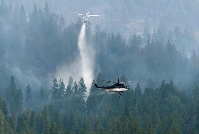
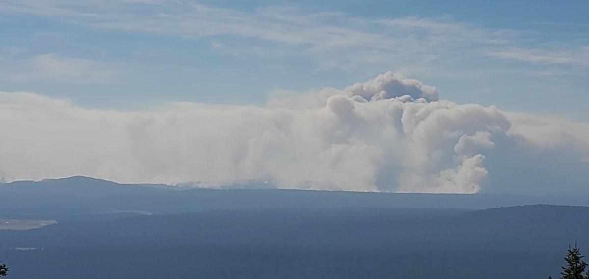
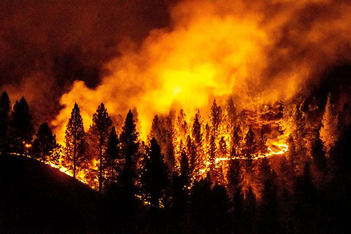
Category Archives: Forest Fires

Forest Fires

Forest fire burning northeast of Lac Saint-Jean headed toward major Hydro plant

CBC News
June 20, 2020
Category: Forest Fires
Region: Canada

Firefighters with Quebec’s forest fire prevention agency (SOPFEU) are battling a major forest fire northeast of Lac Saint-Jean.  The fire has already raged across 58,000 hectares of land and is now headed toward Pipmuacan Reservoir, between the Saguenay–Lac-Saint-Jean and Côte-Nord regions, where there are dozens of cottages, homes, and hunting and fishing camps.  “It’s too early to assess the type of damage, how many cottages have been affected,” said SOPFEU spokesperson Mélanie Morin.  “When we see a perimeter this big, it’s easy to jump to conclusions and think that everything within that perimeter has burned. It may not have.”  The fire is also closing in on the Peribonka Hydro-Québec station, which serves nearly 85,000 customers across the province.    

Read More

Firefighters battling ‘out of control’ near Beaver Creek provincial park

By Danton Unger
CTV News
June 2, 2020
Category: Forest Fires
Region: Canada, Canada West

WINNIPEG — As a wildfire in Beaver Creek Manitoba continues to burn out of control, Manitoba Conservation says six cottages have been damaged by the fire already. As of Tuesday afternoon, Manitoba’s fire map has listed the wildfire as ‘out of control.’ A provincial spokesperson told CTV News the fire started at a peat harvesting area in the region, but the exact cause remains under investigation. The wildfire, which started on Monday afternoon, burned through the night as the Manitoba Wildfire Service, along with the help of the Gimli, Arborg, and Riverton municipal fire departments, continued to fight the fire Tuesday. The map lists the size of the fire as being more than 600 hectares large. Beaver Creek is located about 90 kilometres north of Gimli along the shores of Lake Winnipeg.

Read More

More than 100 people forced out of Pine Creek due to high-risk wildfires north of Dauphin, Man.

By Dana Hatherly
CBC News
May 18, 2020
Category: Forest Fires
Region: Canada, Canada West

Multiple high-risk fires burning in south-central Manitoba have prompted the province to immediately suspend burning permits, after at least 120 people living in some communities north of Dauphin, Man., were forced to evacuate their homes to escape wildfires. High winds had pushed a couple of fires together to create a blaze of approximately 2,500 hectares, according to an emailed statement from a Manitoba government spokesperson late Monday afternoon. The statement said Manitoba Conservation and Climate will not be granting any new permits and will be suspending existing ones within the burning permit area. The Province of Manitoba’s fire situation report earlier Monday said the wildfires burning near Pine Creek, Camperville and Duck Bay spanned about 11 square kilometres. …”Human-caused wildfires have been reported in several other areas of the province as well,” reads the government statement.

Read More

Fort à la Corne fire nears 30,000 hectares

Prince Albert Now
May 18, 2020
Category: Forest Fires
Region: Canada, Canada West

A wildfire burning in the Fort à la Corne forest has nearly doubled in size in the past two days. The English Creek Fire is now estimated at 28,800 hectares, according Saskatchewan Public Safety Agency (SPSA). To give some perspective, that makes the total area of the fire about five times the size of the city of Prince Albert. A SPSA spokesperson said unfavourable wind conditions were continuing to create challenges for crews fighting the fire. The region has an emergency management office that is working with the SPSA to monitor conditions and keep residents of the area informed. A SaskAlert was issued for the area advising of smoke conditions. On Sunday, residents of the R.M. of Torch River and the R.M. of Garden River were told to prepare and be ready to take action should an evacuation be required.

Read More

Fire crews, helicopters battling ‘out of control’ wildfire near Kitimat, B.C.

By Natalia Balcerzak
The Star
May 12, 2020
Category: Forest Fires
Region: Canada, Canada West

A wildfire near Kitimat in northwest B.C. has been classified as “out of control” by the BC Wildfire Service after growing from 15 to 40 hectares overnight. Firefighters suspect it was caused by human activity. The Bish Creek wildfire, located approximately 10 kilometres southwest of Kitimat, has nearly 40 firefighters and two helicopters fighting to contain it as it continues to burn through cutblocks left behind by former logging operations. “It was started in an area where there was no logging activity or no building activity, so we’re confident it wasn’t caused by construction work or logging operations,” Kitimat’s fire chief Trent Bossence said, adding there were no storms or reports of lightning. “We can only assume that it was caused by other means of human activity.” With COVID-19 restrictions limiting access to provincial parks, more people have been visiting the Bish Creek area this year, he said.

Read More

Alberta Wildfire Focusing On Reducing Spring Wildfires

By Cody Gillespie
The Strathmore Now
April 17, 2020
Category: Forest Fires
Region: Canada, Canada West

Alberta Wildfire is preparing for the wildfire season by hiring 200 additional firefighters, invoking a fire ban, implementing off-highway vehicle (OHV) restrictions, increasing fine violations and funding $20 million more in community FireSmart initiatives. The wildfire hazard is highest in Alberta in late April through May. The fire ban will be in the Forest Protection Area, provincial parks, and protected areas. A recreational OHV ban on Crown land in the Forest Protection Area will also be in place. …The fire ban and OHV restriction are temporary measures, which will remain in place only as long as required to combat the wildfire risk. …Fines are being doubled from $300 to $600 for non-compliance with a fire ban and from $600 to $1,200 for non-compliance with an OHV restriction.

Read More

North West Ontario firefighters sent to Quebec

Thunder Bay News Watch
June 24, 2020
Category: Forest Fires
Region: Canada, Canada East

DRYDEN, Ont. — The Ministry of Natural Resources and Forestry has dispatched fire rangers from Northwestern Ontario to help Quebec deal with a serious forest fire situation. Three ranger crews from Thunder Bay, and two crews from Armstrong, were deployed this week to Ontario’s neighbouring province. The 20 firefighters are joined by some overhead staff. In addition, the MNRF has sent two CL-415 waterbombers to Quebec, with nine crewmembers. …The current forest fire danger across the northwest is high to extreme in the Fort Frances, Dryden, Sioux Lookout, Thunder Bay and north shore areas, and low to moderate in western sectors such as Kenora and Red Lake.

Read More

Five new forest fires burning in the northeast region of Ontario

Sudbury.com
June 23, 2020
Category: Forest Fires
Region: Canada, Canada East

SUDBURY, Ontario — There were five new forest fires confirmed in the northeast region by late afternoon on June 22, said the Ministry of Natural Resources and Forestry. Sudbury 23 is being held at one hectare. It is located approximately one kilometre south of route 637. Sudbury 24 measures two hectares and is located east of Big Lynx Lake. Sudbury 25 and Sudbury 26 are in close proximity to one another at 0.2 and 0.3 of a hectare respectively. They are approximately four km east of Garson-Coniston road. …The fire hazard is mostly high to extreme in areas south of Timmins in the region, with the exception of the areas west of Elliot Lake.

Read More

Crews continue to battle Chute-des-Passes wildfire as dozens of forest fires burn across Quebec

By Spencer Van Dyk
CBC News
June 23, 2020
Category: Forest Fires
Region: Canada, Canada East

The Chute-des-Passes forest fire, still burning out of control, has reached the chalet that’s been in Steve Ratthé’s family for 27 years, and he doesn’t know whether the chalet is still standing. According to Quebec’s forest fire prevention agency, SOPFEU, by midday Tuesday, the fire raging north of Lac Saint-Jean in the Saguenay region was burning over about 62,000 hectares — or an area the size of the island of Montreal, plus about half of Laval. Ratthé has been closely monitoring SOPFEU’s fire maps to keep an eye on his chalet, which stood right across the lake from the fire. “Every five minutes there is a change on the maps,” Ratthé told Radio-Canada. “Until we see it, we won’t know.” He left the chalet June 14 and doesn’t know what he will find once he’s allowed to return.

Read More

Forest fires continue to ravage Quebec as authorities hope for rain

By Isaac Olson
CBC News
June 22, 2020
Category: Forest Fires
Region: Canada, Canada East

…Residents have been ordered to clear out of Chute-des-Passes and entry is prohibited as the forest fire there is “out of control,” Public Security Minister Geneviève Guilbault said Monday.  “The heat wave and the drought are unfortunately the perfect recipe for the fires,” she said.  Though several forests are burning in Quebec, the fire north of Lac Saint-Jean is the province’s largest forest fire at the moment. It’s estimated to cover more than 72,000 hectares, which is about one-and-a-half times the size of the island of Montreal.  “Right now, because of the intensity of the fire, there are certain actions we can’t do to stop its progression,” said Mélanie Morin, a spokesperson for Quebec’s forest fire prevention agency (SOPFEU).  That’s because it is impossible to access certain areas on the ground to assess the damage and work to fight the fires directly, she said.

Read More

Smoke, forest fires continue in region

By Ryan Forbes
Kenora Online
June 5, 2020
Category: Forest Fires
Region: Canada, Canada East

Northwestern Ontario residents, particularly those in the Kenora area, can expect to see more smoke in the area today, as forest fires continue to burn near the Manitoba border. The Ministry of Natural Resources and Forestry says the smoke drift was affecting air quality in parts of the region yesterday, and Ontario’s FireSmoke smoke forecast is calling for more smoke over the Kenora area today. In northwestern Ontario, local fire crews found four new forest fires yesterday afternoon. Kenora Fire 15 is not under control at 1 hectare, and is located near Longpine Lake. Kenora fire 16 near Gun Lake is not under control at 0.3 hectares.  Red Lake fire 7 is listed as not under control at 0.5 hectares, and Fort Frances fire 5 is not under control at 1 hectare. This brings the region’s total to five active forest fires.

Read More

One of biggest fires in province since 1990s still out of control near Blackville

CBC News
May 27, 2020
Category: Forest Fires
Region: Canada, Canada East

NEW BRUNSWICK — A fire in the Blackville area continues to burn out of control, consuming more than 800 hectares of forest. The Sabbies River fire has only grown slightly in the past 24 hours, but the estimates of its size grew as smoke cleared and firefighters got a better idea of how much forest it covered. …The fire is turning out to be one of the largest forest fires in recent memory for New Brunswick. …Forty firefighters with two engines, nine tractors and eight air tankers are battling the blaze 18 kilometres south east of Miramichi.

Read More

Dry conditions in Nova Scotia fuelling three large wildfires across province

The Canadian Press in Halifax Today
May 26, 2020
Category: Forest Fires
Region: Canada, Canada East

HALIFAX — Provincial officials in Nova Scotia are warning about the potential for forest fires in dry, humid conditions as firefighters battle three significant wildfires across the province. The fires burning Tuesday follow a weekend blaze near Porters Lake east of Halifax that prompted the temporary evacuation of about 1,000 residents. That fire was under control and was still being patrolled for hot spots. “These three fires today are all in remote areas with no homes nearby,” Jim Rudderham, acting manager of forest protection for the Department of Lands and Forestry, told reporters. …Although no cause has been determined for the latest fires, Lands and Forestry Minister Iain Rankin said it was a good opportunity to warn people that a provincial burn ban is in effect.

Read More

There are eight active forest fires in Northeast Ontario

By Maija Hoggett
Timmins Today
May 26, 2020
Category: Forest Fires
Region: Canada, Canada East

ONTARIO — As of this afternoon, no new forest fires had been discovered, according to the Ministry of Natural Resources and Forestry… there are eight active fires in the northeast region. All are being held, under control or being reserved. The active fires are: Kirkland Lake 1 is under control at 15.8 hectares; North Bay 3 is being observed at 1 hectare; Parry Sound 5 is under control at 0.1 of a hectare; Pembroke 5 is being held at 7 hectares; Sudbury 13 is under control at 0.9 of a hectare; Sudbury 14 is being held at 10 hectares; Sudbury 15 is under control at 4.8 hectares; Peterborough 1 is under control at 25 hectares.

Read More

2nd forest fire in Miramichi area being fought near Blackville

By Gail Harding
CBC News
May 25, 2020
Category: Forest Fires
Region: Canada, Canada East

Fire crews are battling a second forest fire in the Miramichi region in as many days.  Kelly Cormier, a spokesperson for the Department of Natural Resources and Energy Development said Monday afternoon there is a fire out of control  about 18 kilometres southeast of Blackville in the Savvies River area. The fire is about 200 hectares in size.  “Six air tankers are currently working on the fire and two additional air tankers are on route from Quebec,” Cormer said.   “At this time no homes are in danger.”  The forest fire in Barnaby that started Sunday afternoon was listed as under control Monday night. At one point, three homes were in danger but air tankers and fire crews managed to keep the fire at bay. 

Read More

N.S. firefighters battle multiple fires across the province

CBC News
May 25, 2020
Category: Forest Fires
Region: Canada, Canada East

Firefighters across Nova Scotia will resume the fight Tuesday morning to contain at least two major forest fires and two smaller fires that broke out amid high winds, dry conditions and warm temperatures.  The provincial Department of Lands and Forestry had crews and helicopters working alongside local fire departments Monday afternoon and evening to contain blazes in Havre Boucher in Antigonish County, the Springfield area of Kings County, the Argyle area of Yarmouth County and the Grand Mira South area in Cape Breton.  The fire in Havre Boucher, about 40 kilometres east of Antigonish, is considered out of control, according to Lands and Forestry.  Six volunteer fire departments, Lands and Forestry ground crews and two helicopters responded to the fire, which is now about 200 hectares in size.

Read More

Forest fire in Chester Grant now contained

By Haley Ryan
CBC News
May 22, 2020
Category: Forest Fires
Region: Canada, Canada East

A forest fire near Chester Grant, N.S., that erupted Friday evening is now contained, according to the province’s Lands and Forestry department.  The fire covered an area of about 27 hectares and razed at least two buildings to the ground.  Crews returned to the area at first light on Saturday to continue fighting the forest fire. They had suspended their efforts overnight. “It’s pretty quiet there this morning, or quieter than last night,” Jim Rudderham, acting manager for forest protection in Nova Scotia, said late Saturday morning. “No open flames, just hot spots to be put out.”  Most firefighters left the scene just after 9 p.m. Friday, after putting out “a large part of the fire,” according to the Department of Lands and Forestry.

Read More

Crews contain more than half of Porters Lake brush fire

By Haley Ryan
CBC News
May 24, 2020
Category: Forest Fires
Region: Canada, Canada East

Fire crews have contained more than half the area of a large brush fire in Porters Lake on Sunday.  In an update as of 12:30 p.m. AT Sunday, the Department of Lands and Forestry said the is still active but is now 60 per cent contained.   “There is no active fire front,” the department said via Twitter.   Helicopters have been mapping and monitoring the fire status.  Grace and Charles Whitford were some of the first residents asked to leave Saturday afternoon as part of the evacuation order for about 170 homes along West Porters Lake Road.  “It was scary,” Grace said Sunday morning when the couple stopped into the comfort centre for evacuees in Lake Echo.  Charles first saw smoke around 12:30 p.m. AT Saturday, and within 20 minutes or so RCMP were knocking on their door to tell them they had to leave right away.  

Read More

North Bay 6 forest fire under control, North Bay 3 being observed

By Mary Beth Hartill & Doug Crosse
North Bay Nipissing News
May 24, 2020
Category: Forest Fires
Region: Canada, Canada East

NORTH BAY —  There are still two active forest fires in North Bay.  A fire known as North Bay 6, which is five hectares large and started on Wednesday, May 20 at 6:47 p.m., is considered under control. It is located in West Nipissing’s Crystal Falls area, 25 kilometres northwest of North Bay, some 18 kilometres from the shores of Lake Nipissing.  And a fire known as North Bay 3, which is one hectare large and started on Monday, May 18 at 2:41 p.m., is being observed. It is located north of the Kenny Forest Provincial Park, some 52 kilometres north of North Bay.  In the northeast region, the fire hazard ranges from moderate to extreme. The areas of most concern are in the Pembroke, Gravenhurst, Elliot Lake, Mattawa and Powassan areas.

Read More

Residents evacuated for Porters Lake blaze east of Halifax allowed to return home

The Chronicle Journal
May 24, 2020
Category: Forest Fires
Region: Canada, Canada East

PORTERS LAKE, Nova Scotia – Residents of more than 500 homes that were threatened by a forest fire in an area east of Halifax are being allowed to return now that officials have lifted an evacuation order. Halifax Fire tweeted late Sunday afternoon that the order for West Porters Lake area was ended, noting the weather has been in firefighters’ favour. Word of the fire first emerged early Saturday afternoon, leading to the closure of area roads and the evacuation of more than 150 homes, involving more than 1,000 residents. …The tweet says residents were being allowed to return home as of 6 p.m. local time, although it noted a highway exit would remain closed until 9 p.m. this evening.

Read More

Dry weather yields an active fire season, pushing Quebec’s firefighters to capacity

CBC News
May 24, 2020
Category: Forest Fires
Region: Canada, Canada East

Firefighters in Central Quebec were able to save dozens of homes near Saint-Étienne-des-Grès by dropping thousands of litres of water over a forest fire that burned 25 hectares of forest. Crews from six neighbouring municipalities were called in when the fire broke out on Friday night. …”We were really concerned for several residences,” said Mayor Robert Landry. Several ground crews were still on site on Sunday morning to ensure the fire is entirely out, said Mélanie Morin, a prevention and communications officer for SOPFEU, Quebec’s forest fire prevention agency. …The warm, dry weather in southern Quebec these past weeks created ideal conditions for fires to spread, Morin said. Across the province, fire crews are working at full capacity, putting out 20 new fires every day on average. With 315 fires total this season, 2020 has seen more than double the number of fires usually recorded at this time of year, which is normally closer to 150.

Read More

Water bombers dispatched to Poplar Hill First Nation forest fire

Thunder Bay News Watch
May 20, 2020
Category: Forest Fires
Region: Canada, Canada East

DRYDEN, Ont. — The Ministry of Natural Resources and Forestry dispatched water bombers Tuesday afternoon to attack a new forest fire not far from the remote community of Poplar Hill first Nation. The fire, which is not under control, had burned 23 hectares at last report. It is located about seven kilometres southeast of the community. …Elsewhere in northwestern Ontario, three wildfires broke out on and around the territory of Pikangikum First Nation over a period of two days.

Read More

Wildfire risk ‘above normal’ for northeastern Ontario

By PJ Wilson
The North Bay Nugget
May 6, 2020
Category: Forest Fires
Region: Canada, Canada East

While predicted forest fire conditions for this year are “above normal” for most of northeastern Ontario, it’s impossible to say if the region will see a repeat of the summer of 2018. Ellen Whitman, a fire research scientist with Natural Resources Canada’s Northern Forestry Centre in Edmonton, says conditions may be similar, but… there are other factors at play that will determine whether it will be a problem year for wildfires. “What the forecast shows is that conditions are above normal” for factors such as temperature and drying conditions. But it was the number of lightning strikes that made 2018 such a devastating fire season. …The “forecast severity anomaly” is expected to be well above normal across Western Canada from B.C. to the Ontario-Manitoba border, but above normal through Ontario and Quebec.

Read More

Three new forest fires burning in region

The Thunder Bay News Watch
April 29, 2020
Category: Forest Fires
Region: Canada, Canada East

KENORA, Ontario – There are three new forest fires burning in the Northwest region, with one listed as not under control. According to the Ministry of Natural Resources and Forestry, all three fires are located in the Kenora region. A 6.6 hectare fire that started on April 25 and is located on Northwest Angle First Nation is listed as being under control. A second fire located on Wabaseemoong Independent Nation and 0.1 hectares in size is listed as not under control. A 2.5 hectare fire also located on Wabaseemoong Independent Nation is 2.5 hectares in size and is being held. A restricted fire zone remains in effect across the province due to the COVID-19 outbreak. 

Read More

Homes evacuated as 1,800-acre fire burns south of Helena; pre-evacuation issued near county line

By Jess Chaney
Helena Independent Record
June 13, 2020
Category: Forest Fires
Region: United States

HELENA, Montana — About 20 homes were being evacuated after a wildfire sparked in Jefferson County south of Helena Saturday, and a pre-evacuation notice was issued near the Lewis and Clark County line.  Jefferson County Deputy Fire Warden Pat McKelvey said the size of the fire was estimated at 1,800 acres Saturday evening. Officials have not yet released information about the cause. The fire is burning in the Lump Gulch area near Sheep Mountain and has produced a significant amount of smoke in the Helena area. ….McKelvey said 30-40 mph winds were initially blowing from south to north but were expected to begin blowing from west to east, which was part of the reason for the evacuations.

Read More

Arizona wildfires grow as flames flicker throughout Desert Southwest and California

By Matthew Cappucci and Andrew Freedman
The Washington Post
June 22, 2020
Category: Forest Fires
Region: United States, US West

Wildfires continue to rage in Arizona, leading into another week set to feature hot, dry conditions from the Desert Southwest to California. At the same time the fires are burning, prompting evacuations, spikes in coronavirus cases are being recorded in several states in the region, including Arizona.  The fifth-largest wildfire in Arizona’s history continued to rage Monday morning, swelling to 186,086 acres. The so-called Bush Fire northeast of Phoenix had torched an area seven times larger than Disney World and 13 times larger than the island of Manhattan. It was 42 percent contained, with more than 700 personnel working to fight the flames.  State Route 87, northeast of Phoenix, was closed from Payson to Bush Highway, spanning 52 miles of the roadway. Routes 188 and 88 also experienced closures as well. And it was just one of a spattering of blazes dotting the region.

Read More

Giant wildfire near Phoenix continues to grow as Arizona coronavirus cases spike

By Tim Stelloh
NBC News
June 18, 2020
Category: Forest Fires
Region: United States, US West

A massive wildfire just northeast of Phoenix continued to burn through thousands of acres of desert and forestland Wednesday, triggering evacuations as Arizona is also dealing with a spike in coronavirus cases. The so-called Bush Fire in Tonto National Forest has grown to nearly 90,000 acres — up from 64,000 on Tuesday — and was only 5 percent contained, according to InciWeb, the U.S. Forest Service’s wildfire information site. The blaze began Saturday with a car fire. Amid mostly sustained winds of 25 mph to 30 mph, it quickly spread through terrain that includes Sonoran desert and canyon lands to ponderosa pine forest, said Dee Hines, a spokesman for the team fighting the fire. “It’s kind of like a chimney, the way the wind goes up the canyons,” he said. “Between the terrain and the wind, it’s been a really challenging fire.”

Read More

State seeing a spike in the number of wildfires

Payson Roundup
June 17, 2020
Category: Forest Fires
Region: United States, US West

A spike in the number of wildfires this year is concerning fire management officers as resources become spread thin and fires compete for firefighters, equipment, and aviation. As of Tuesday, June 16, 941 wildfires have burned nearly 170,000 acres of private, federal, and tribal lands. Last year, during the same time frame, 689 fires burned close to 47,000 acres of land. Nearly all, 95%, of this year’s fires are human caused, and while a majority of the fires are not intentional, they are preventable. Department of Forestry and Fire Management investigators found multiple ignition sources, including an abandoned campfire, fireworks, and cigarette butts at the point of origin on the Stage Fire, near New River, back in May. The multiple ignition sources made it difficult for investigators to pinpoint the exact cause of the fire.

Read More

Bush Fire increases to 14,371 acres

By Alexis Bechman
Payson Roundup
June 16, 2020
Category: Forest Fires
Region: United States, US West

A fire that broke out north of Fountain Hills this weekend that is being driven by hot, dry and blustery conditions has shut down the Beeline Highway and led officials to evacuate Punkin Center and Tonto Basin residents. The Bush Fire on the Tonto National Forest was at 14,371 acres as of Monday morning and 0% contained. Fire officials say the fire is burning quickly through grass and brush into the Four Peaks Wilderness… The human-caused fire started Saturday… Because of the fire’s growth and movement, the communities of Punkin Center and Tonto Basin were asked to evacuate Monday morning. …Weather forecasts for the fire area continue to call for hot, dry and windy conditions, which will make it difficult for crews to stop the fire’s forward progression. …Several other fires have started across the state in what promises to become a white-knuckle fire season…

Read More

No New Growth Expected For Wildfire South Of Helena

By Edward O’Brien
Montana Public Radio
June 15, 2020
Category: Forest Fires
Region: United States, US West

There was minimal growth Monday on a wildfire burning near Clancy, south of Helena. Strong winds fanned the Lump Gulch fire Saturday afternoon which led to the mandatory evacuation of around 20 homes over the weekend.  Incident spokesman Duane Buchi says fire behavior was very quiet Monday.  “Once things calmed down a little bit and we got the rain on top of that, and cooler temperatures; yeah it’s really moderated. No expected growth at this point beyond the perimeter.”  The latest mapping has revised the fire’s size down to 1,100 acres, from 1,500 acres.  All mandatory evacuations have been lifted and all pre-evacuation notices for Lewis and Clark County were lifted Sunday.  

Read More

Wildfire near Cody grows to nearly 600 acres

By Juliana Sukut
Billings Gazette
June 14, 2020
Category: Forest Fires
Region: United States, US West

A wildfire that broke out Saturday on Shoshone National Forest land about 25 miles west of Cody has grown to nearly 600 acres. The fire has activated three U.S. Forest Service engines, three Bureau of Land Management engines, four air tankers, three helicopters and the Park County Fire Department, according to Kristie Salzmann, Shoshone National Forest public affairs officer. The cause of the fire remains under investigation, Salzmann said in a press release. On Saturday, two ranches were evacuated due to safety concerns from the fire, which also briefly closed portions of U.S. Highway 14-16-20. …Saturday evening Salzmann said the fire was 0% contained. 

Read More

UPDATE: Bighorn Fire grows to 2,550 acres, drone again causes trouble for crews

KOLD News 13
June 8, 2020
Category: Forest Fires
Region: United States, US West

ORO VALLEY, Ariz. – The Bighorn Fire in the Santa Catalina Mountains north of Tucson has burned around 2,550 acres as of late Monday, June 8. A drone flying in the area Monday may have hurt the effort to battle the blaze. The containment was at 10 percent Sunday and officials said it stayed that way Monday, likely thanks to the drone. “The percentage of containment has not increased, and acreage burned has increased largely due to this illegal drone incursion,” said Incident Commander Lathe Evans. “If You Fly, We Can’t!” It was the second time since in three days a drone caused crews to stop their work. Officials said the fire is still moving northeast into Table Mountain.” Crews said they will continue to focus on keeping the fire from moving south, where many homes are found. …The fire was ignited by lightning in the Coronado National Forest late Friday, June 5.

Read More

Quail Fire near Winters leaps to 1,200 acres, destroying 2 structures, threatening 100 more

By Michael McGough
The Sacramento Bee
June 6, 2020
Category: Forest Fires
Region: United States, US West

A fast-spreading wildfire fueled by strong winds in Solano County continued to burn through the night after prompting mandatory evacuation orders and doubling in size in less than 90 minutes Saturday evening, authorities said. The Quail Fire burned at least 1,200 acres and was 5 percent containment, Cal Fire’s Sonoma-Lake-Napa unit said in an update just before 9 p.m. At 7:45 p.m., the blaze had scorched 600 acres not far from Putah Creek and Lake Solano County Park. Officials from the California Department of Forestry and Fire Protection said at least two structures were destroyed and 100 buildings were threatened. …In an 11:15 p.m. update, Cal Fire said 600 personnel were assigned to the blaze and more resources were in en route. Officials said numerous firefighting air tankers had flown fire suppression missions “as conditions allow.”

Read More

Sawtooth Fire in the Superstition Mountains at 2,500 acres, 0% containment

By Alana Minkler
AZCentral
June 1, 2020
Category: Forest Fires
Region: United States, US West

A lightning-caused wildfire in the Superstition Mountains is estimated to cover 2,500 acres and is burning in all directions, according to a tweet by the Tonto National Forest.  The fire is 0% contained and has closed the Peralta Trailhead.  No structures have been burnt or threatened yet. The wildfire is northwest of Gold Canyon, located on state and Tonto National Forest land, right on the “scar” of the 2019 Woodbury Fire, which began on June 8 in the Superstition Wilderness and burned more than 123,800 acres, causing the evacuation of homes, road and campground closures, endangered wildlife habitats and the destruction of hiking trails.  

Read More

Hundreds evacuated as wildfires rage in Florida Panhandle

By Bobby Caina Calvan
The Associated Press in US News
May 7, 2020
Category: Forest Fires
Region: United States, US East

…The blaze near Milton, Florida, was one of several fires burning through the Panhandle that scorched thousands of acres of woods, razed dozens of structures, including homes, and forced some 1,600 people to evacuate from their neighborhoods. The 2,000-acre fire in Santa Rosa County, located just east of Pensacola, prompted the evacuation of 1,100 homes Wednesday. Officials said a few of those residents, in areas south of Interstate 10, have been allowed to return to their homes, although others have been told to stay away. There have been no reports of injuries or deaths. Officials said 13 homes were destroyed so far in the fire dubbed the Five Mile Swamp Fire. Because of the coronavirus pandemic, some evacuees were sent to nearby hotels to avoid potential problems with crowding. Firefighters continued battling the erratic fire deep into the night Thursday. With only 35% of the fire contained, it could be days before it can be brought under control, officials said.

Read More

Mississippi Forestry Commission monitoring two wildfires

WGNO News
May 8, 2020
Category: Forest Fires
Region: United States, US East

JACKSON, Mississippi– The Mississippi Forestry Commission said crews are monitoring two large fires yesterday, one in Hancock County and one in Harrison County. While the fires remain active, our crews do have them contained,” said MFC State Forester Russell Bozeman. Bozeman said crews worked overnight to contain both fires. The fire in Harrison County was contained at approximately 500 acres and the Hancock County fire was contained at approximately 1,000 acres. …Over the past several weeks, south Mississippi has experienced very little rainfall. This paired with high winds and low relative humidity is a recipe for potentially catastrophic wildfires. Much of the rest of the state is also experiencing weather conditions that are prime for wildfire outbreaks.

Read More

Hundreds evacuated as wildfires rage in Florida Panhandle

The Asscicated Press in ABC News
May 7, 2020
Category: Forest Fires
Region: United States, US East

PENSACOLA, Florida — Firefighters in the Florida Panhandle battled wildfires through the night that have forced hundreds of people to evacuate from their homes, authorities said. A more than 575-acre fire in Walton County prompted about 500 people to evacuate. Authorities there said multiple structures were lost in the fire, which was 65% contained Thursday morning. Another wildfire broke out Monday afternoon in neighboring Santa Rosa County as high winds and low humidity caused the blaze to expand 10 times in size, the Florida Forest Service said in a statement. The fire started as a prescribed burn but quickly grew out of control, according to The Tampa Bay Times. The Forest Service said multiple structures have been lost in the 2,000-acre fire in the Santa Rosa County and authorities are recommending residents south of Interstate 10 to evacuate. 

Read More

Indonesian province declares state of emergency over forest fires

Reuters
July 1, 2020
Category: Forest Fires
Region: International

JAKARTA – Indonesia’s third-largest province declared a state of emergency from Wednesday after identifying more than 700 fires, as the Southeast Asian nation braces for its annual fire season. The declaration comes as Indonesia scales back protection for some of the world’s most important tropical forests. The team that identifies fires and helps put them out has seen its budget halved due to the economic impact of the coronavirus, an environment ministry official told Reuters last month. The province of Central Kalimantan said the state of emergency will run until Sept. 28. The level of emergency is at the first ‘alert’ stage which calls for increased patrols and early extinguishing efforts.

Read More

Wareham Forest: Fire extinguished after nearly two weeks

BBC News
May 30, 2020
Category: Forest Fires
Region: International

A forest fire that has been burning for almost two weeks has been extinguished.  The blaze at Wareham Forest in Dorset started on 18 May but flared up in high winds over subsequent days leaving about 550 acres (220 hectares) damaged.  Initially it may have been started by a disposable barbecue or camp fire, investigators believe.  Dorset and Wiltshire Fire Service (DWFRS) said they will be maintaining a presence at the site until Monday in case hotspots emerge.  A spokeswoman said: “We believe the fire to be extinguished but we are still maintaining a presence because of hotspots [in case they emerge].”

Read More

Wareham Forest fire flare-ups continue to spread after six days

BBC News
May 23, 2020
Category: Forest Fires
Region: International

Strong winds are still helping spread a forest fire which has been burning for six days in Dorset. More than 150 firefighters remain at Wareham Forest dealing with hotspots and flare-ups. About 500 acres have so far been damaged. A helicopter was brought in to “water bomb” the area as smoke drifted as far as Bournemouth. Dorset and Wiltshire Fire and Rescue Service said winds of up to 45mph were proving a “huge risk”. Officials have urged people to avoid the area. …The blaze, which started on Monday, may initially have been started by a disposable barbecue or camp fire, investigators believe. …One third of the 3,700-acre forest is designated as a Site of Special Scientific Interest and is home to rare birds, plants and invertebrates. On Wednesday, Forestry England estimated it could take the forest “decades” to recover.

Read More