 Sandy McKellar at Tree Frog News recently interviewed the team at Forsite Consultants to learn more about innovative inventories and how they are used in forest management. Forsite Consultants Ltd is a leading-edge forest management company with offices in BC and across Canada. Together their team brings unique approaches to forest inventory to provide added-value to their natural resource clients. The Forsite interview panel included Cam Brown, strategic planning forester and manager of the Resource Management and Technology group; Mike Parlow, Inventories Team Lead; and Carleigh Drew, marketing specialist. McKellar’s interview explores how Forsite uses LiDAR to create innovative operational forest inventories and how digital twinning of timber on the strategic land base can bring data to life.
McKellar: Can you describe your role in providing innovative forest inventories for clients?
 Brown: We help our clients manage their land base with the best information possible. LiDAR and imagery solutions are now incredibly powerful at describing forest structures and providing key attributes – even down to the individual tree level. My role is one of helping clients understand the possibilities that different technologies bring to the forest inventory business, and then matching them with solutions that will bring a return on investment to their situation.
Forsite can take clients all the way from data acquisition to predicted forest attributes. Another aspect of our role is to look for any new methodologies or technologies which will help to improve the accuracy of forest inventories.
McKellar: Why is there a lot of innovation happening around forest inventories right now?
 Brown: For many years, remote sensing using imagery looked promising but never quite delivered because of inconsistency over large areas (shadows, clouds, etc). Now, the use of Machine Learning approaches using satellite imagery taken repeatedly over the same area, is helping to eliminate this issue and is producing good products with limited attribute lists. Additionally, the use of Synthetic Aperture Radar is being used to estimate stand heights, and Semi Global Matching applied to stereo images is able to create 3D point clouds describing the surface of the forest.
But the single biggest disruptor in the inventory world is LiDAR – a very pure data form generally not impacted by clouds, shadows etc) which provides incredibly detailed information on both terrain and vegetation. The 3D point clouds from LiDAR penetrate deeply into stands and can be used to directly measure key features in forest inventories (height and crown cover), as well as predict a wide range of other attributes.
 Drew: It sounds like you’re saying the data set can now accurately reflect what’s on the ground, rather than being interpreted. So the LiDAR data is objective rather than subjective?
Brown: Exactly. New processing techniques have also reduced the cost to produce the data.
Parlow: As the technology has matured, higher point densities have become economical and really open up some exciting new territory.
McKellar: What are the general themes of innovation taking place?
Brown:
- Finer spatial scales (operational scale inventories) 20x20m tiles or individual tree crowns, micro stands
- More detailed attributes like log product volumes, tree lists, understory detection, etc.
- Automation / Machine Learning
- Faster product creation (months instead of years)
- Consistent results – less subjectivity than photo interpretation
- Measurements instead of estimates (height, CC)
- Predictions of attributes like species, stems/ha and piece size
McKellar: What have been the biggest challenges?
Brown:
- Predicting tree species has been a challenge. Individual tree species identification requires very specialized approaches but solutions have emerged. I will say that nature is messy (all lodgepole pine trees don’t look the same) so solutions will never be perfect, but they are good enough to be quite useful.
- Creating strategic inventory products from detailed operational inventories requires grouping very small areas into stands. Assigning age and site index to each stand is still an evolving area. LiDAR data does not help directly with age or site productivity – but we are using alternative approach to fill in their attributes.
- Changing an inventory system that has been in place since the 1920s. There are a lot of established systems to manage and grow traditional inventory products so any new products need to be able to fit within that structure or find alternatives ways to achieve the same goal.
McKellar: What does an ‘innovative’ forest inventory look like?
Brown:
It can be as simple as 10x10m or 20x20m tiles with Height, Basal Area, % softwood/hardwood, and volume/ha assigned to each one. This provides a lot of fine spatial detail that can be used by operational planners.
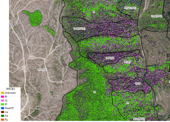 It can also be as detailed as a single tree inventory (species, ht, diameter, log products, etc) which is very powerful for operational planning, and can also be used to create replacements for traditional inventory products. This is done by attempting to capture and attribute every tree crown in the AOI using LiDAR data, followed by aggregation of this data into small areas (400m2) which can then be compared to ground sample plots and adjusted to reflect the plot data. These tiles provide an extremely rich set of attributes to describe the forest, including volumes by species, height, Basal Area, stems/ha, crown cover, etc.
McKellar: What are the key differences from traditional inventories?
Brown:
- They provide information to use at operational scales (fine spatial scales and very detailed attribute list)
- Strategic inventories can be directly linked to operational level detail. (trees –> small areas –> polygons –> forests)
- Faster / consistent / objective. Human input is now used to build/train algorithms instead of estimating every attribute on every polygon.
Drew: The data is scalable? With data at an individual tree level, which can be rolled up to an area, a polygon, and a landscape level?
Brown: Yes, an individual tree dataset can be used by operational planners at a 1:1000 scale, while aggregations of this data can be used at landscape or forest level scales.
Parlow: What’s being provided now is the Digital Twinning of the merchantable timber on the landscape.
Drew: Can you explain ‘Digital Twinning’?
 Parlow: At its most basic level, digital twinning is the mapping of real-world processes and assets to a digital platform. The goals of digital twinning are as you would expect; reduce risk, save time, increase ROI. We can recognize the steps already taken in forestry towards this goal and the potential benefits that a full implementation of digital twinning could bring. For background, here at Forsite we’re creating the digital assets that feed into the digital process side of the equation. Our systems and those of our competitors create the digital representations of individual trees across a landscape. In the past 12 months we’ve segmented over 500 million individual trees out of LiDAR data, enabling each with a full set of attributes including species, height, estimated DBH, live crown percentage, and estimated product specifications.
McKellar: What is still ‘work in progress’?
Brown:
- Many areas are constantly being refined, but the big picture is now in place. Often it’s now a choice about what level of detail (spatial / attribute) you need for your area (coarser = imagery, finer = LiDAR, finest = LiDAR individual tree)
- We are currently working on finding better ways to estimate site productivity and/or age at fine spatial scales
McKellar: It’s clear that Forsite has a unique value proposition. What kind of companies/organizations could benefit from your services and how can our readers engage with your team?
Brown: Our clients range from large and small forest licensees to community forests, government and First Nations. With nine locations across Canada in BC, Alberta, Saskatchewan and Ontario we are well positioned to engage with forestry clientele throughout Canada. I would encourage anyone looking to learn more about our services visit our website to find the nearest office, or reach out to me directly. I’d be pleased to help.
Cam Brown, MF, RPFBC – Resource Analysis
Tel: 250.832.3366 (Ext 220)
Email: cbrown@forsite.ca