![]()
![]() Wildfire management is of critical importance. In many cases, contemporary landscapes have been altered from their natural condition due to a variety of factors including decades of fire suppression causing a build-up of fuels to unnatural and non-historical levels. Furthermore, societal values are intermixed into, and surrounded by, these forests. This allows wildfires, fueled by a warming climate, to result in catastrophic consequences when fire occurs proximal to communities. A key part of wildfire management is understanding the factors that influence fire behaviour: fuel, weather and topography. As land managers, our opportunity to make a difference is through active fuel management to reduce potential fire behaviour. As such, it is imperative that we have the best available information when making management decisions.
Wildfire management is of critical importance. In many cases, contemporary landscapes have been altered from their natural condition due to a variety of factors including decades of fire suppression causing a build-up of fuels to unnatural and non-historical levels. Furthermore, societal values are intermixed into, and surrounded by, these forests. This allows wildfires, fueled by a warming climate, to result in catastrophic consequences when fire occurs proximal to communities. A key part of wildfire management is understanding the factors that influence fire behaviour: fuel, weather and topography. As land managers, our opportunity to make a difference is through active fuel management to reduce potential fire behaviour. As such, it is imperative that we have the best available information when making management decisions.
Fuels can be broken down into measurable or descriptive subcomponents consisting of size, moisture content and continuity. While all of these are measurable at a small scale, such as in a single stand, trying to account for these attributes within the expansive variability of our ecosystem types is not practical. Forsite’s team of fire experts is well-versed in the challenges of working with traditional fuel type classes, and recently published research (Baron et al. 2024) has brought to the public eye the challenges of working with a constrained system of fuel classes applied across our highly diverse land base in Canada.
Through the provision of funds from the Innovation Solutions Canada program in 2023, Forsite Fire, in collaboration with Ember Research Services, embarked on developing two product streams that improve the accuracy of fuel typing by using remotely sensed data. Our first product, the Wildfire Fuel Generator (WFG), quickly produces maps for fire response and planning using satellite-derived metrics and proprietary machine-learning technology to classify environmental characteristics into one of the benchmark fuel types. Our second product, FuelID, relies on both LiDAR data and machine learning technology to derive detailed fuel characteristics. While the WFG can generate coarse resolution datasets (e.g., 100 x 100 m), both products are available at high spatial resolution, down to 10 x 10 m.
Using the WFG, FBP fuel types are built using a variety of satellite-based data layers and published fuel typing algorithms (where available) to improve on both resolution and accuracy of existing provincial and national fuel type maps. Where fuel typing algorithms exist, FBP updates are completed by integrating satellite and LiDAR-derived metrics within machine learning algorithms that are tuned with fuel typing methods in mind. Our high-resolution FBP maps provide greater accuracy and detail than existing layers, enabling better wildland fire management and predictive modelling applications. We are designing these products with the next-generation FBP fuel types in mind so we can deliver more detailed information on the forests that surround the range of values across the landscape and facilitate a better understanding of expected fire behaviour and problem areas to prioritize treatment and management.
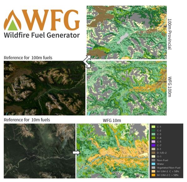
Example Fire Behaviour Prediction (FBP) fuel type maps are shown with reference imagery from the Esri Imagery Hybrid Basemap. The first comparison shows an example of currently available FBP fuel maps at 100 x 100 m resolution compared to the Wildfire Fuel Generator (WFG) product. The second example shows the WFG FBP fuel layer at 10 x 10 m resolution. There is no provincially or federally available layer for comparison at such high resolution.
Using FuelID, the mapping of detailed fuels involves implementation of machine-learning technology that utilizes LiDAR, and high-quality field data to predict a large range of canopy, ladder, and surface fuel characteristics. FuelID implements components of Forsite’s proprietary TreeID individual tree segmentation algorithm to generate highly effective predictor variables from LiDAR point cloud data. Predictive models have been designed for 56 different fuel characteristics and tailored towards a variety of environmental planning needs. Applications for this data include fuel management planning and prescriptions; fuel treatment review and efficacy; post-disturbance succession monitoring; habitat assessments; land management; ecological, fire or carbon modelling; and research. Our team is using these highly detailed fuel maps to facilitate landscape fire modelling using models that incorporate separate attributes for the different forest strata, enabling a more accurate assessment of how treatments and landscape disturbance affect fuel types in our highly variable landscape, especially when modified fuel treated areas don’t fit into the standard FBP fuel type boxes.
Forsite Fire is supporting improved fire response and wildland fire management through creating more accurate and effective fuel typing to allow for better decision making. Phase 2 of product development is expected to start by summer 2024 and will focus on continuous improvement of our methods to ensure the best possible information is available and development of a portal where users can access the data layers for a variety of management uses.
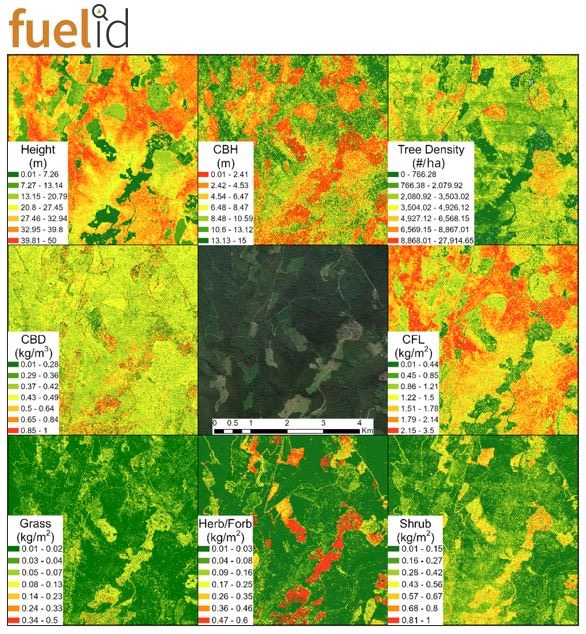
A sample of the possible FuelID data layers is shown here in comparison to background imagery from the Esri Imagery Hybrid Basemap. Tree height, canopy base height (CBH), tree density, canopy bulk density (CBD), crown fuel load (CFL), grass, herb/forb and shrub fuel loads are shown.

John Davies
If your community wants to learn more about how to prepare itself strategically and tactically from a wildfire, please feel free to reach out to John Davies, our Senior Wildland Fire Specialist & Forsite Fire Manager at Forsite Fire: jdavies@forsite.ca or visit forsite.ca/services/wildfire.
This article is part of our partnership with the Western Canada SFI Implementation Committee (WCSIC) and our jointly hosted Wildfire Resilience and Awareness Week.